Gray shading over your town on a wildfire smoke map can sit right beside a green air quality reading, and both can be accurate at once. Don't take your indoor air for granted on the strength of either one alone! The shading tracks smoke in the sky. The colored circle tracks the air your family actually breathes.
A current wildfire smoke map for the USA today provides valuable insights into smoke movement, nearby wildfire activity, and changing air quality conditions. By understanding the different map layers, including satellite smoke plumes, ground-level AQI readings, and smoke forecasts, homeowners can stay informed, plan outdoor activities with greater confidence, and take practical steps to maintain healthier indoor air.
TL;DR Quick Answers
current wildfire smoke map USA today
A current wildfire smoke map of the USA today shows three live layers: satellite fire detections, NOAA smoke plumes graded light, medium or heavy, and ground-level AQI readings. Here’s something that might surprise you: the shading shows smoke overhead, while the nearest colored AQI circle shows the air your family actually breathes.
Fire Icons: Satellite heat detections and reported fires, refreshed through the day.
Smoke Shading: NOAA posts its first daily analysis between 11 a.m. and noon Eastern, so early views can lag.
AQI Circles: Green is good, orange affects sensitive groups, and red or higher means limit time outside.
Forecast Layer: HRRR-Smoke projects where smoke drifts over the next 48 hours.
Indoor Action: Close the windows, set the AC to recirculate with the fan on On, and run a MERV 13 filter if your system allows it.
Top Takeaways
Trust the AQI circle for the air you breathe, and treat plume shading as smoke overhead.
Check the timestamp, since NOAA's satellite smoke analysis usually posts late morning Eastern.
Lean on HRRR-Smoke forecasts for direction and timing rather than exact levels.
Distance from a fire won't keep smoke out of your neighborhood.
Close up the house, set the AC to recirculate, run the fan on On and use a MERV 8 filter if your system allows it.
What a Wildfire Smoke Map Actually Shows
Most live maps stack fire, smoke and air quality data on one screen, and each layer has its own job.
Fire detections show up as dots or flame icons. Satellites flag the heat, agencies add reported incidents, and together they tell you where the smoke starts.
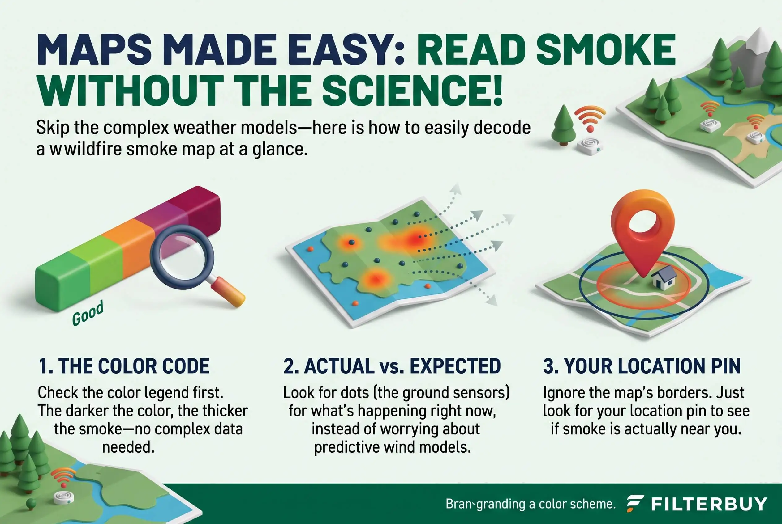
Smoke plumes appear as gray or tan shading. NOAA's Hazard Mapping System traces them from daytime satellite images and grades each area light, medium or heavy.
Air quality readings are the colored circles. Ground monitors and sensors produce them, and each one carries a score on the Air Quality Index, or AQI. These outdoor readings can also help homeowners recognize when wildfire smoke may increase the risk of indoor air pollution, making it important to check ventilation and filtration.
Overhead Smoke Isn't Always the Air You Breathe
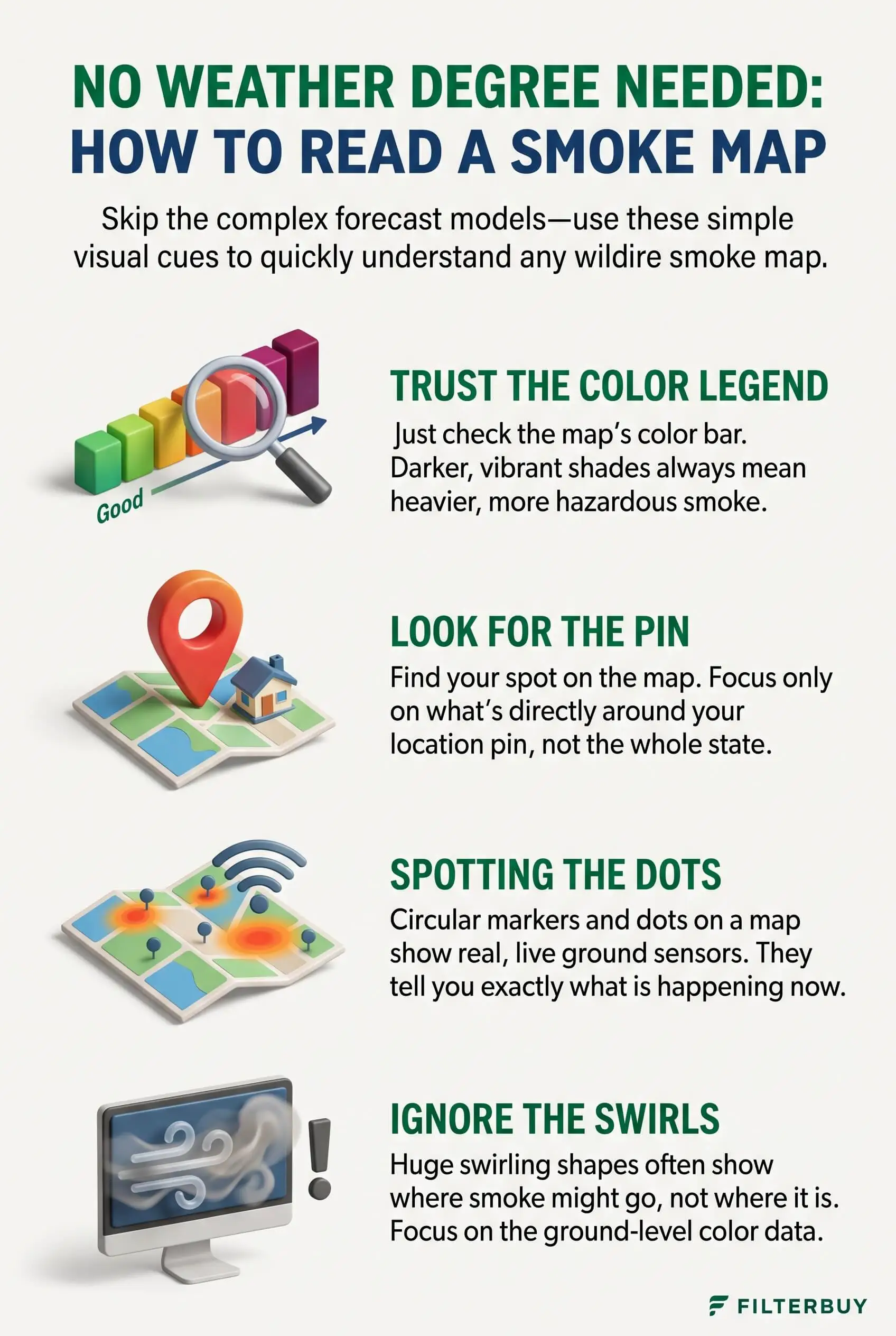
Here's something that might surprise you: plume shading counts smoke anywhere in the column of air above you, sometimes miles up. Wind can carry a thick layer high over your neighborhood while the air at street level stays fairly clean. Calm mornings can flip that, trapping smoke low enough to push your AQI up. So let the colored circle, not the shading, decide what your family does next. Along with monitoring air quality, understanding the ideal temperature for air conditioning systems can help homeowners maintain indoor comfort while keeping windows closed during wildfire smoke events.
How to Read a Wildfire Smoke Map in Five Steps
Check the timestamp first. NOAA usually posts its first smoke analysis of the day between 11 a.m. and noon Eastern and adds a second most evenings, so a 9 a.m. glance may still show yesterday's plume.
Find your home and read the shading. Light, medium and heavy describe how dense the smoke looks from space. Heavy shading gives you a reason to look closer, but it doesn't settle anything.
Tap the nearest air quality circle. This number matters most for your lungs. Note its color and which way the trend is heading.
Flip on the forecast layer. Most maps let you switch from observed smoke to a forecast covering the next day or two, which shows whether conditions are improving or sliding.
Make your plan before the smoke gets in. Decide on windows, outdoor time and AC settings while the air inside still beats the air outside.
Reading Smoke Forecasts Without Weather Model Jargon
Behind the forecast layer on most U.S. smoke maps sits a NOAA computer model called HRRR-Smoke. Treat it as a best guess at where today's smoke drifts next. The National Weather Service says full runs come out every six hours and reach 48 hours ahead, and it points most people to the near-surface view.
You only need to watch a few things as the frames advance. Track which way the plume stretches. Darker shading moving toward your area raises the odds of poor air, so keep an eye on that too. Then note when the forecast shows smoke arriving or clearing, and plan errands around that window.
No model gets it perfect, and the NWS says so plainly. Use the forecast to spot trends and your current AQI reading to confirm them. Keeping high quality filters ready can also help maintain cleaner indoor air when wildfire smoke reaches your area.
Smoke Shading and AQI Colors Use Different Scales
This one trips up plenty of people. Shading measures smoke density overhead, while AQI colors measure health risk at ground level.
Green, 0 to 50: Good. Open the windows if you like.
Yellow, 51 to 100: Moderate. Unusually sensitive people may want to cut back on long stretches outdoors.
Orange, 101 to 150: Unhealthy for sensitive groups, which includes kids, older adults and anyone with asthma or heart disease.
Red, 151 to 200: Unhealthy for everyone, so limit time outside.
Purple, 201 to 300, and maroon, 301 and up: Very unhealthy to hazardous. Stay inside with filtered air.
Why Smoke Reaches Homes Far From Any Fire
Fine smoke particles can ride the wind for hundreds or even thousands of miles. This year's wildfire season proved it early, when spring grass fires tore across the Plains. The Morrill Fire alone burned more than 640,000 acres and became the largest wildfire in Nebraska's recorded history. That's how a home with no fire anywhere in its state can still sit under an orange circle for days.
What to Do Indoors When the Map Shows Smoke Over You
Smoke carries particles called PM2.5, small enough to slip through gaps and basic filters. You're the hero of your household here, and most of these changes take little effort for a big impact.
Shut the windows and doors, and close any fresh-air intake.
Set the AC to recirculate and the fan to On. EPA guidance explains that On keeps air moving through the filter all the time, instead of only when the system cycles.
Upgrade to a MERV 13 filter, or the highest rating your system can handle, as the EPA recommends, and make sure it fits snugly. This guide to choosing the right MERV rating walks through the tradeoffs.
Check the filter more often, because smoke loads it fast. Swap it once it turns gray, and use this overview of how often to change an AC air filter as your baseline.
Set up one clean room with an ozone-free portable air cleaner sized for the space, ideally where your family spends the most time.
Wear a well-fitting NIOSH-approved respirator such as an N95 if you have to head outside, as the CDC advises.
Pro Tip: Buy a spare high-efficiency filter in your size before smoke season starts. That way you won't be hunting for one on the first hazy morning.
"In my years servicing home HVAC systems through smoke seasons, I've pulled MERV 13 filters that turned gray within days of a heavy smoke event, well ahead of their usual replacement date. I tell homeowners to let the AQI circle decide when to act and let the filter show how hard the system is working."
7 Essential Resources
Current Wildfire Smoke Map USA Today: Live fire detections, light to heavy smoke layers, observed and forecast smoke, and an AQI overlay in one view.
Wildfires and Indoor Air Quality: The EPA's advice on filters, HVAC settings and portable air cleaners for smoke days.
NOAA Hazard Mapping System Fire and Smoke Product: Where the satellite plume shading comes from and when NOAA updates it.
HRRR Smoke Model Tutorial: A National Weather Service walkthrough of the smoke forecast loop.
Safety Guidelines: Wildfires and Wildfire Smoke: CDC health steps, respirator advice and guidance for people at higher risk.
Research to Help You Breathe a Little Easier: How U.S. Forest Service air resource advisors build the smoke outlooks behind public maps.
NASA Satellite Observations and Tools for Fire and Smoke Monitoring: NASA training on FIRMS and Worldview for anyone curious about the raw satellite view.
3 Supporting Statistics
The National Interagency Fire Center counted 64,393 wildfires and about 9.03 million burned acres in 2026 as of October 14, running at 132% and 143% of the 10-year average for that date. National Interagency Fire Center: National Fire News
The American Lung Association's 2026 State of the Air report places 76 million people in counties that earned a failing grade for year-round particle pollution. American Lung Association: Key Findings
A 2021 PNAS study led by Marshall Burke found that wildfires accounted for up to 25% of PM2.5 across the U.S. in recent years, and up to half in some western regions. PubMed Central: The Changing Risk and Burden of Wildfire in the United States
Final Thoughts and Opinion
Here's my honest opinion: smoke maps feel complicated because they put the sky and the ground on one screen. Pull those two apart and the map gets a lot friendlier. Shading says smoke is around. The circle says whether it has reached you, and the forecast hints at what's coming next.
I'd rather check one AQI circle twice a day than sit through plume animations trying to play meteorologist. With U.S. fire counts running well above average this year, I think a fresh high-efficiency filter and a daily AQI check belong on every homeowner's list, whether you live in Oregon or Ohio. Homeowners exploring air ionizer installation services should also consider how these systems fit into their overall indoor air quality strategy, particularly during wildfire smoke events.
Is the Gray Area on a Smoke Map the Air I'm Breathing?
Not necessarily. Gray shading shows smoke somewhere in the air column above you, and that smoke may sit well overhead. Check the nearest AQI circle to see what's happening at ground level.
What Do Light, Medium and Heavy Smoke Mean?
These labels describe how dense the smoke looks in satellite images. Heavy shading raises the odds of poor air, though only a ground reading can confirm it.
How Accurate Are Wildfire Smoke Forecasts?
They do a good job with direction and timing and a weaker one with exact levels. The National Weather Service recommends pairing any forecast with your current AQI.
How Often Does a Live Smoke Map Update?
Satellites refresh fire detections throughout the day. NOAA usually posts its smoke analysis between 11 a.m. and noon Eastern, then runs a second pass most evenings.
Should I Run My AC When Wildfire Smoke Is Nearby?
Yes. Run it on recirculate with a high-efficiency filter and the fan set to On. With a window unit, the EPA says to close the outdoor air damper, and to skip the unit during smoke if you can't close it.
Read Any Smoke Map With Confidence
You can protect your home from wildfire smoke without understanding a single weather model, as long as you check the AQI circle first and the forecast second. Pair that habit with closed windows, a running fan and a filter built for fine particles, and your family can breathe easier through every smoke season. You can also learn how to test indoor air quality to better understand whether smoke particles are affecting the air inside your home.